The Quilotoa Loop: Our First Multi-Day Hike
Epic views at Laguna Quilotoa
Leaving Quito rested and refreshed, we arrived in Latacunga on a sunny, Sunday afternoon to start the week with a new challenge: our first multi-day hike.
We hadn’t planned on doing too much in Latacunga - its the jumping off point for the Quilotoa Loop, which we would start the next day, and a good place to return to, so we were able to leave the big backpacks and take only what we need for the trail. However, we didnt expect the city to be a ghost town. We struggled to find somewhere open for lunch!
So we spent most of our afternoon on the roof terrace in our hostel, and it turned out to be a slice of good fortune that we did. Across the afternoon we were joined by Marc and Marina (from Quebec), Sophie (from Sweden), and Mike and Ana (from the Netherlands). We had a lovely afternoon learning about each other’s travels and lives, sharing beers as the sun set over the city, then heading out to dinner as a group - the only restaurant open in town was luckily right across the road from our hostel.
Graeme and I are always amazed - and immensely grateful! - that when people of different nationalities get together they all converse in English. It makes it very easy for us! But it also makes us so aware of how bad we are at other languages. There we were, sitting with 5 other people who were not only speaking fluently in their second language, they were making jokes and being hilarious whilst doing so. We know from the interactions we have in Spanish that it is tiring speaking in another language for a short amount of time, so we are suitably in awe of the travellers we meet who do this.
We all planned to be on early morning buses in the direction of Quilotoa in the morning, however Graeme and I were the only ones heading anti-clockwise on the loop and hiking for 3 days. The others all planned to bus clockwise, directly to Quilotoa Lake for a day of hiking around the crater, and return to Latacunga. So we said goodbye as we got on separate buses (a comically long goodbye for a group of people we had only known for 12 hours!) and got on the bus in the direction of Sigchos, where the trail for the Quilotoa loop begins.
On our bus was Mark, an American who had been in our dorm the night before. We got chatting to him and learnt he was planning on doing the same route we were - but he was doing it all in a day! Almost 40km at altitude. My motherly instincts set in: does he know how long the hike is? Does he know how hard it is? He isn’t going to make it - he has such a tiny backpack!
After a short conversation with him we realised he did in fact know what he was doing. He was a trail runner, a cross country skier and regularly ran 100km+ at altitude. So 40km would probably be a warm up for him… and here we were feeling super adventurous about a 3 day hike!
We got off the bus and bid Mark good luck before starting the trail ourselves at a much slower pace. Here is how it went.

Day 1: Sigchos to Isinlivi
Stats:
Starting Altitude: Sigchos 2850m.a.s.l
Finishing Altitude: Isinlivi 2950m.a.s.l
Distance: 12km
Total time: 4-6 hours (we did it in 4.5 hours)
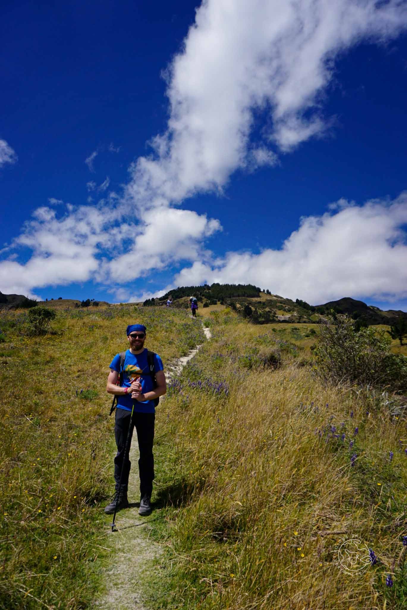
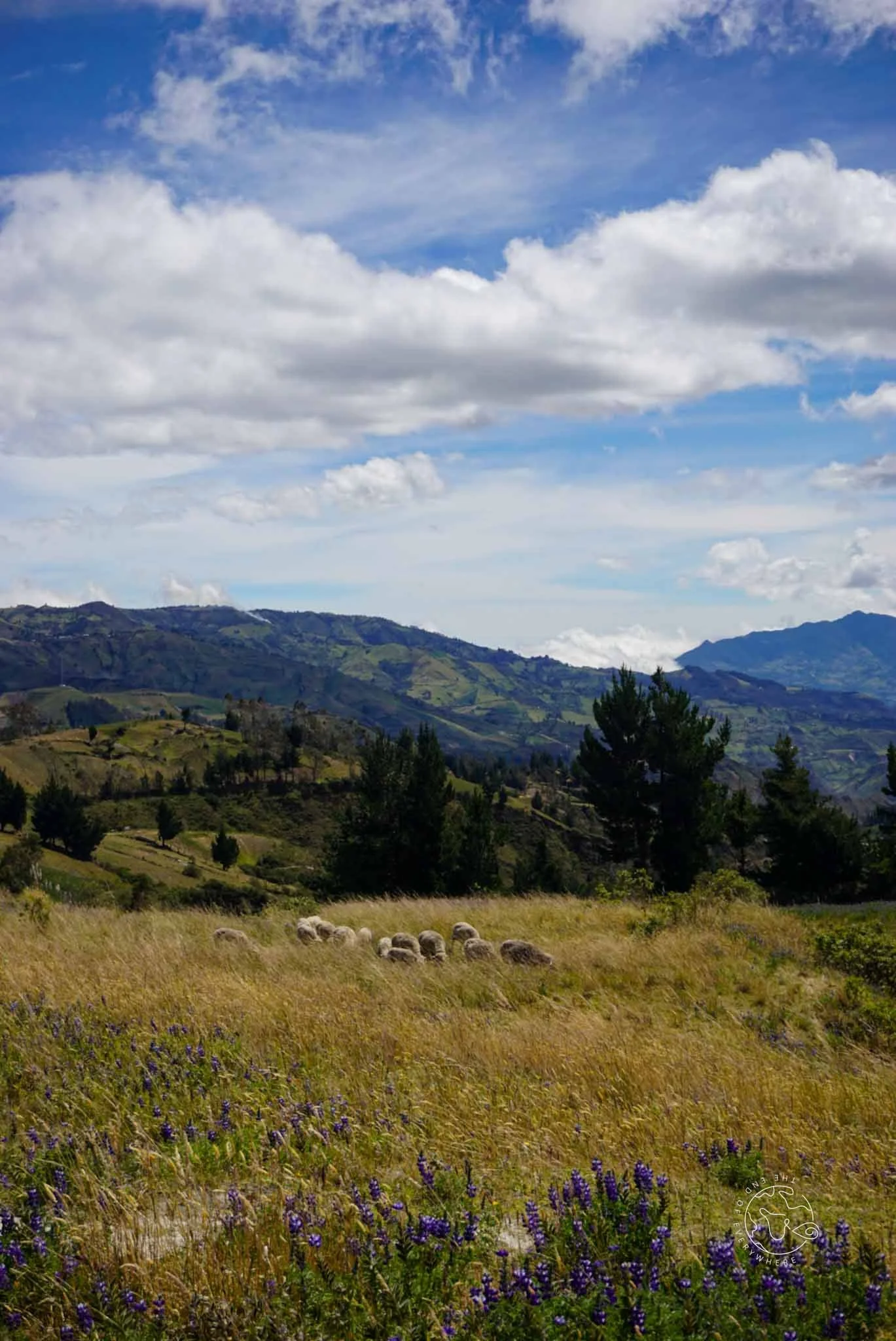
The first day on the trail really let us know what we had signed up for. There was, of course, the good: incredible views that seemed to get better and better through the day. It was like walking through a painting. From green fields to babbling rivers and a winding trail cutting across the hillsides and disappearing into the valleys, the surroundings were unlike anything we have ever seen.
The unexpected: whilst we were ready for the challenge of hiking at altitude and had spent our time in Quito and Latacunga acclimatising, we didn't realise quite how up and down the trail would be. We were mentally prepared to be hiking +1000m over three days. But our route took us over ridges and down into valleys multiple times - descent and ascent, repeat. So over the three days we actually climbed a lot more than 1000m!


On day 1 the trail was fairly well marked, and our offline Maps.me app proved its worth - although we were hesitant to trust it at first after the fail in Salento! There were a few bits that puzzled us, like when the app and the signs were pointing along the path that was closed with barbed wire. After some hesitation, we chucked our bags under and climbed under - and then motioned for some hikers to do the same when we saw them having the same indecision below us. It wasn’t so easy the second time we came to this situation, as a cow had decided to relieve itself directly where we needed to crawl! Luckily there was just enough space to squeeze around the side of the fence. As we had struggled with our bags, we waited for the next group to help them get their bags over the gate. They were all French-speaking and were grateful for the help, and we ended up passing each other a few times on the rest of the trail to Isinlivi.
Of course, it wouldn’t be Graeme and I if we didn’t get pointlessly lost somewhere along the way! Once we had the village of Isinlivi in sight, we got excited that we were almost done and began chatting away… completely missing the road to the village. We walked on for about 15 minutes before we realised we were actually getting further from where we needed to be! Not a huge drama, but not what our legs needed after 4 hours of walking.

We got to our hostel and the group we had passed on the trail were already there - it was just the six of us checked in. They were actually two couples who had met in Latacunga and embarked on the trail together that day- Francios and Celia, from Belgium, and Geoffrey and Kim from France. We enjoyed dinner (included in our hostel rate) and conversation with the group that evening before an early night.
Day 2: Isinlivi to Chugchilan
Stats:
Starting Altitude: Isinlivi 2950m.a.s.l
Finishing Altitude: Chugchilan 3200m.a.s.l
Distance: 12km
Total time: 4-6 hours (we did it in 4 hours)
Day 2 started with a hearty breakfast and collecting a surprisingly huge lunch box from our hostel, before getting an early start on the trail. We set off only a few minutes ahead of the others, so it wasn’t long before they caught us up (when we were dithering over which way to go - classic!) and we walked along as a group. It was really nice to have company, but we felt bad as we didnt want them to have to speak English for our benefit!

We learnt that Francios and Clelia were the pace-setters; they regularly hike in the alps and it showed, as there were several times they sped off ahead of us, barely breaking a sweat whilst we were gasping for breath! But we all went at our own pace and were never too far from each other.
The hardest part of the day was climbing up a narrow path with almost vertical drop off, right from the side of the river in the valley up to the ridge of the mountain. It was so tough! We stopped for lunch at the top, all sat in single file along the ridge eating our sandwiches. It was incredible.
Along the way we bumped into Mike and Ana, our friends from Latacunga, travelling the opposite way! They had been persuaded to do the trail at the last minute and were tackling it in the opposite direction, having started at Quilotoa Lake the day before.
Arriving in Chugchilan later that day, we were in the same hostel as Geoffrey and Kim again for the evening. The hostel owners said we were the fastest hikers and first to check in for the day - definitely thanks to Francios and Clelia’s pace-setting! It was a much more popular place, with around 30 hikers all staying for the night.
At dinner, we met a couple from Newcastle (Graeme zoned in on the Geordie accent!) who were coming to the end of their extended trip. It was great to hear their experiences of Central America and get excited for all we have to come.


Day 3: Chugchilan to Quilotoa
Stats:
Starting Altitude: Chugchilan 3200m.a.s.l
Finishing Altitude: Quilotoa 3900m.a.s.l
Distance: 14km
Total time: 6-8 hours (we did it in 6.5 hours)
Day three was in fact the hardest and longest day of hiking. We set off early with Geoffrey and Kim, passing a lot more people on the trail. About an hour into the day Francios and Clellia caught up with us and our little group was reunited.
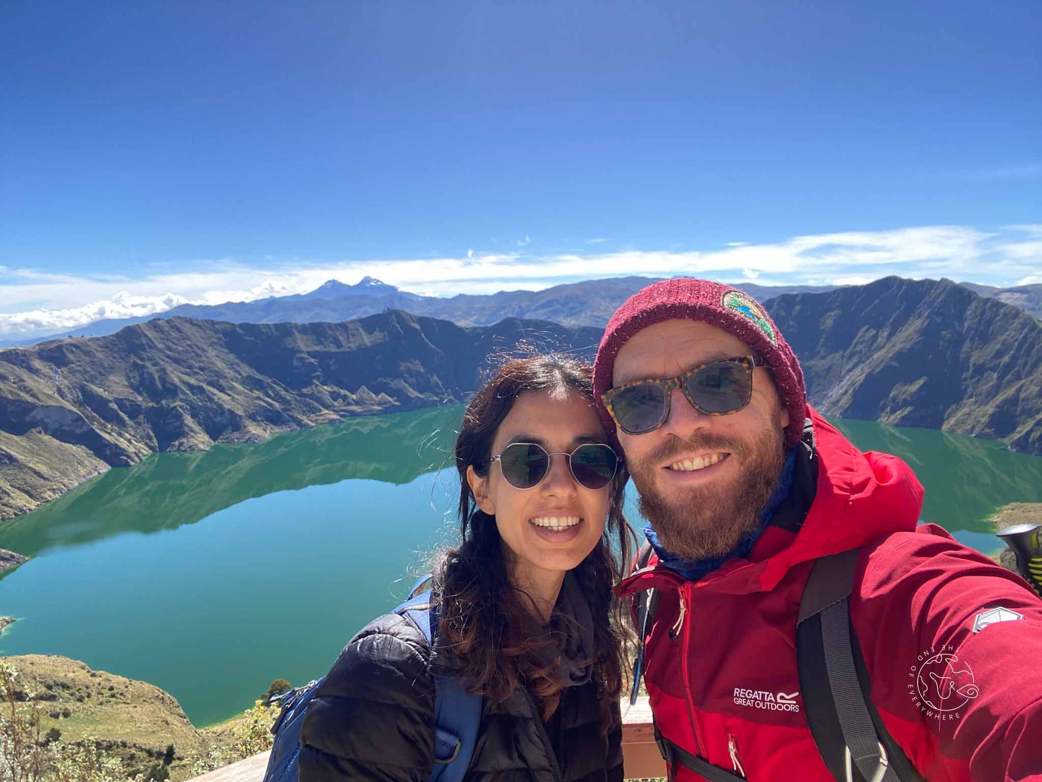
The slope of Quilotoa was ahead of us all day, a target for us to aim for. Most of the trail panned out in a similar way to the previous two days, but there was a marked change in the trail as we got closer to the crater. We were scrambling up volcanic sand, steeper and steeper, until the view of the lagoon revealed itself to us. A truly incredible sight, it made every breathless, sweaty, painful moment of the previous two days completely worth the effort.


We all pulled layers on immediately as we were exposed to the cold wind on the crater, and then stopped for so many pictures. We felt like we might be holding the others up a little, but we made so much effort to get there we were definitely going to capture the moment!
It was then another 1.5 hours walk around the rim of the crater to the town of Quilotoa. Every turn seemed to reveal a new angle of the lagoon, and the shifting clouds changed the colour of the lake, so there were a lot more photo stops!


Arriving in Quilotoa, we found the town to be geared up for tourists in a way we hadn’t experienced on the loop - understandable, as it is a popular and accessible day-trip location. Before saying goodbye to our hiking companions we shared a few beers (and paid the tourist-town prices for them!) and got to know each other a little better. It’s strange that we experienced something so amazing together and we probably won’t see each other again!
Graeme and I went off in search of our hostel for the night, only to find they had cancelled our booking due to having no water supply. As we hadn’t had mobile signal all day, we had been unaware of this! So at 5pm we scrambled around town looking for another room, and ended up paying a lot more than expected. But we had shelter and were comfortable after a hard day, so we were very grateful. We even managed a game of chess before bed. I’m not a chess strategist, I play without much thought to what I will do next, so I expected to be quickly beaten… but I had Graeme worried for a while before he made the breakthrough!
After a good sleep we woke up with a variety of options for the day. We could either go down to the lake to kayak, or spend another day walking around the entire crater rim. In truth, neither option appealed to us!
We had already completed a third of the crater rim walk on our way to Quilotoa, so another day walking and repeating 2 hours of yesterday’s walk did not appeal. Kayaking on the lake would have been nice, but the path down to the boathouse was a 400m descent, and our legs didn't feel like they could handle the 400m, 2 hour climb back up!
So with our final morning in Quilotoa we walked a short way around the crater to a mirador that we hadn’t already passed, and we soaked in the morning sunshine with that magical view before us.
Related Content


